EGU24: Harnessing modern 3D gravity analysis techniques
A study of the Ligurian offshore area
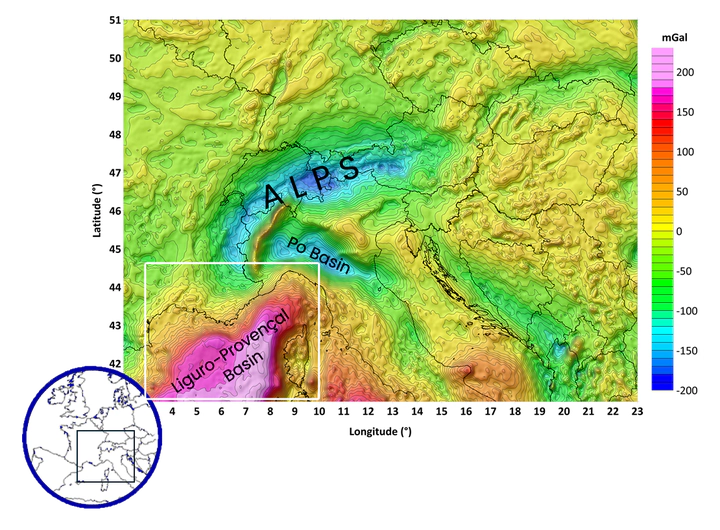 The new Bouguer gravity map of the Alps and adjacent areas compiled by AlpArray Gravity Research Group (Zahorec et al., 2021). The white box in the southwest indicates the modeled area.
Abstract
This interdisciplinary study describes the integration of gravity field analysis, curvature techniques and various spatial applications. The data are based on land-based Free Air and Bouguer gravity data from the AlpArray Gravity Research Group, complemented by recent satellite missions. New seismic and seismological data from the AlpArray initiative and the German 4D-MB Priority Program were used as independent boundary conditions for the 3D modeling and inversion of the gravity data. Prior to this modeling, Euler deconvolution, terracing/clustering techniques, and advanced filtering methods were employed to reveal intricate details of the region’s gravitational signatures. For example, a distinct zoning of gravity is observed in the central part of the Ligurian Sea, pointing to traces of past rifting processes. Analysis of various curvature parameters (e.g., dip-, min-, max- and shape-curvature) of the processed gravity fields, in particular gradients and residual fields support the identified zonation of the gravity fields, which reflect the geological structures in the crust. The final 3D modeling of the Ligurian Sea area is based on a previous density model of the entire Alpine region and includes density distribution of the upper mantle. These densities were derived from tomographic velocity models, accounting for petrology, temperature, and pressure. Additional information of the upper crust was obtained from the refraction seismic results of the LOBSTER project, offering a comprehensive understanding of spatial phenomena. Calculations of the gravitational potential energy (GPE) provide additional information on local stresses, facilitating a deeper understanding of the flexural rigidity in the area. By elucidating the relationship between processing techniques and 3D modeling, this work advances interdisciplinary interpretation crucial for geological studies in the Ligurian offshore area.
Highlights
), visualized for comparison purposes. Below one can see the model crust with different crustal structures ([Spooner et al., 2019](#SpoonerEtAl2019)) down to a depth of 50 km. The mantle voxel cube (dark brown) contains the upper mantle velocities converted to densities according to [Kumar et al. (2022)](#KumarCacaceEtAl2022).](/igmas-pages/talk/egu24-harnessing-modern-3d-gravity-analysis-techniques/model_views_hu837260afdfd43baa06e1760b75d40160_222855_a087b0ec164cdeeabe6c59cbb49ac899.webp)
References
Materials
The Ligurian Sea on the map:
View Larger Map
Related
See also other contributions on EGU24 related to IGMAS+:
For more information please visit: https://www.egu24.eu
![]()